July 14–18, 2026 · Wyoming Mormon Trail Sites
Getting There
Every mile of the drive is part of the story. Here is the route from Parowan to our base camp at Sixth Crossing, and how to reach each trek site during the week.
Parowan → Sixth Crossing
We caravan as trek families, departing the stake center at 7:00 AM (arrive 6:30 AM). It is about 575 miles — plan on 9 to 10 hours with fuel and lunch stops. Campground check-in is between 1:00 and 8:00 PM. Your GPS will handle this whole route — set it to Sweetwater Campground (the pin is linked below).
- 1I-15 North. From the Parowan stake center, take I-15 north through Beaver, Fillmore, and Provo to Salt Lake City (about 250 miles).
- 2I-80 East. In Salt Lake City, merge onto I-80 east toward Cheyenne. Climb Parleys Canyon, pass Evanston into Wyoming, and continue to Rock Springs (about 185 miles).
- 3US-191 North. At Rock Springs, take Exit 104 onto US-191 north toward Farson (about 41 miles). Farson is the last reliable fuel and restroom stop — top off here.
- 4WY-28 East. At the Farson junction, turn right onto WY-28 east. Cross South Pass (about 65 miles). You’ll pass the Atlantic City turnoff and the Rock Creek Hollow sign — the same road we’ll use Saturday.
- 5US-287 / WY-789 Southeast. WY-28 ends at US-287. Turn right (southeast, toward Rawlins) and continue about 30 miles to Sweetwater Station.
- 6Sixth Crossing. About a mile past the WY-135 junction at Sweetwater Station, the Sixth Crossing Visitors’ Center sits on the hill south of the highway. Follow the entrance road to Campgrounds #2 and #3.
Base Camp — Sixth Crossing Campgrounds #2 & #3
We camp all four nights at the Sweetwater Campgrounds on the Sixth Crossing property, just below the visitors’ center on US-287 (about a mile east of Sweetwater Station, 40 miles southeast of Lander). Wednesday’s Martin’s Cove trek is the only day with a long drive — Thursday and Friday start close to camp.

Camp layout — we’re in Campgrounds #2 and #3, next to the handcart corral.
- GPS: Sweetwater Campground on Google Maps ↗ — coordinates 42.52340, -108.20605 (address backup: 4181 State Highway 789, Lander, WY 82520)
- Check-in: 1:00–8:00 PM · Quiet hours: 10:00 PM–6:00 AM
- Facilities: 30×60 pavilion, hand-pump well, picnic tables, fire rings, vault toilets
- The visitors’ center (running water and restrooms) is up the hill from camp
Getting to Each Trek Site
Each morning we caravan from camp as families. Arrive at every trailhead 45 minutes before your start time.
Martin’s Cove — about 1 hour east
From camp, head east on US-287 (toward Rawlins) about 45 minutes to the Muddy Gap junction. Turn left onto WY-220 toward Casper; the Mormon Handcart Historic Site entrance is a few miles ahead on the left, just past Devil’s Gate. GPS works fine: 47600 W Highway 220, Alcova, WY 82620.
Open in Google Maps ↗Sixth Crossing — right at camp
No highway driving today. The Willie Handcart trail and the Sweetwater crossing are on the Sixth Crossing property — the trailhead is about 3 miles southwest of the visitors’ center. Follow the caravan from camp to the trailhead parking. The Women’s Pull happens along this trail, and the visitors’ center is open afterward.
Rocky Ridge — Sage Campground trailhead, about 40 minutes
From camp, drive west on US-287 about 3 miles (2 miles past Sweetwater Station), then turn left onto the Hudson–Atlantic City Road (Fremont County Road 2302) — a well-maintained dirt road. Follow it southwest with the caravan, keeping it under 30 mph to avoid flat tires. Park at the Sage Campground turn-off from the Fort Stambaugh–Atlantic City road and walk down to the campground and trailhead — vehicles stay up top. The medical truck can haul the water jugs down, so don’t carry them. From Sage Camp we hike the 9.5-mile Rocky Ridge loop. GPS: Sage Campground, Sweetwater Station, WY 82520 (coordinates 42.48590, -108.42364) — but stay with the caravan.
Open trailhead in Google Maps ↗Rock Creek Hollow — read this one carefully
Two things to remember:
1. DO NOT drive through Atlantic City.
2. DO NOT use your GPS if it directs you through Atlantic City.
GPS routes vehicles onto rough roads through Atlantic City that are not suitable for vans and trailers. Use the turn-by-turn directions below instead.
- 1Follow US-287/789 west for 30 miles towards Lander, WY.
- 2At the intersection, turn left on WY-28 and drive approximately 22 miles.
- 3CONTINUE PAST THE ATLANTIC CITY–SOUTH PASS HISTORIC SITE TURN-OFF. DO NOT TURN HERE.
- 4You will pass some rock walls in the mining area.
- 5You will pass the Louis Lake turn-off about 20 miles down WY-28 — you’re getting close to the turn-off.
- 6About 2 miles past the Louis Lake turnoff, you will see a brown sign that reads “Natl Historic Place, Rock Creek Hollow, Willie Handcart 1 Mile.”
- 7Turn left on the gravel road at the Natl Historic Place sign and follow the signs to Rock Creek. The first Rock Creek sign is about 1.6 miles down the dirt road, with more signs at 2, 3.7, and 7 miles.
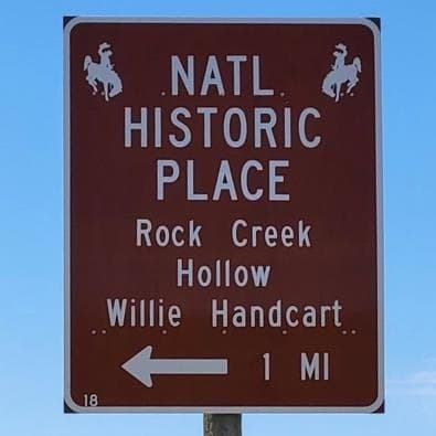
The turn-off sign on WY-28 — your cue to turn left
Once on the gravel road, you’ll pass these signs in order — keep following Rock Creek:
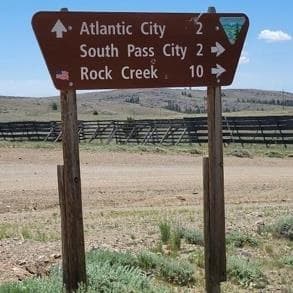
Sign 1
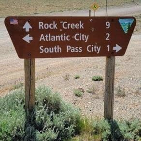
Sign 2
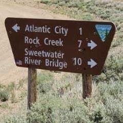
Sign 3
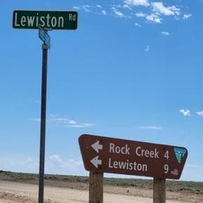
Sign 4
To reduce the chance of flat tires, do not exceed 30 miles per hour on the dirt roads. After the closing devotional, return to WY-28 and turn left (southwest) — you’re already on the road home: over South Pass to Farson, US-191 south to Rock Springs, then I-80 west and I-15 south to Parowan.
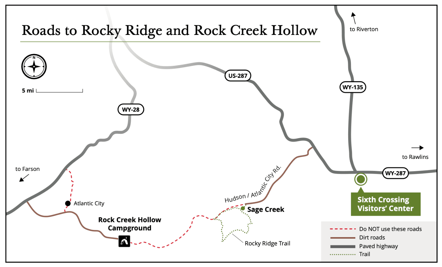
Friday and Saturday at a glance — brown roads are dirt, the red dashed roads through Atlantic City are the ones to avoid.
Drivers: print the one-page handout to keep in the vehicle — Rock Creek Hollow Driving Directions (PDF)
Have a beautiful time at this sacred site.